The main objective of action coordinated by Unitus, was to integrate information from different data sources collected under other projectual actions regarding statistical information at farm level, geospatial data sets on land cover, statistical information on the impacts of carbon farming practices, in a GIS-based infrastructure (GIS-FARM). This methodology focuses on defined areas within the Lombardy Region where C-farming practices are implemented, i.e. a management of agricultural land able to compensate for CO2 emissions concentrates on agricultural activities both through the sequestration of CO2 in the upper layer of the soil and the possible reduction of CO2 emissions.
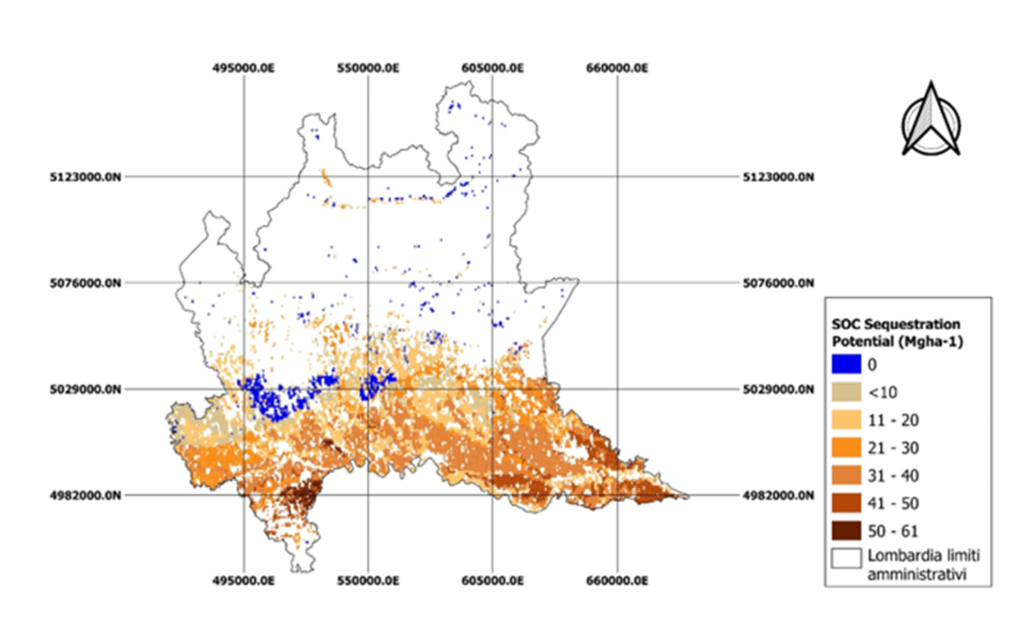
The platform has a double final objective, indeed, on one hand it is for public authorities at regional scale and on the other hand is aimed at farmers. At public scale, the main objective was to provide reliable information on: i) the current stocks of soil organic carbon (SOC) in the topsoil, ii) the carbon sequestration potential of the soil in relation to local environmental conditions. Regarding the farm scale, the main objective of GIS-FARM is to provide robust values of SOC change considering individual agricultural areas, based on the potential for CO2 sequestration and/or reduction of emissions considering the carbon practices application defined in the previous action. From a methodological point of view, the work was divided into 4 main sections: i) grouping within the Lombardy Region of homogeneous areas for the mitigation potential deriving from the application of carbon farming practices, ii) characterization of the carbon content Soil Organic (SOC) used to associate the initial levels of SOC in the soil with the spatial units deriving from layer stratification, iii) evaluation of the sequestration potential of SOC in Lombardy agricultural soils, iv) analysis of the scenario of carbon farming at the scale of agricultural parcel. The project has generated new and reliable information layers on the initial SOC level of agricultural soils and their associated carbon sequestration potential. Figure 1 shows one of the information outputs that highlights the carbon sequestration potential of Lombard agricultural soils in Mg ha-1.
Based on the approach described above, the following key results were achieved within this action:
CARBON POTENTIAL SEQUESTRATION IN THE SOIL OF AGRICULTURAL LANDS OF THE LOMBARD REGION: through the map carried out the 60% of the total regional agricultural area could be subjected to a realistic assessment of the carbon sequestration potential.
SCENARIOS AT COMPANY-SCALE OF CARBON FARMING PRACTICES: the main limitations in simulating carbon farming practice scenarios were the availability of data and the wide heterogeneity in terms of treatments. The agricultural land for which scenarios of total SOC variation are available with the application of carbon farming techniques amount to almost 54% of the total agricultural area. The sequestration scenarios of SOC in the surface soil of annual crops are between 0.36 (treatment: organic amendments) and 0.86-0.96 Mg ha-1year-1 (treatments: conservative or organic agriculture or organic amendments and green manure or mulching cover crops).
TECHNICAL REFERENCES ON THE COMPLETENESS OF GIS-FARMS DATA: in general, the partial coverage of the data currently offered by the GIS-FARMs platform on a regional and corporate scale is largely linked to the quality and limited availability of data used as initial input.